Fenwick Mines
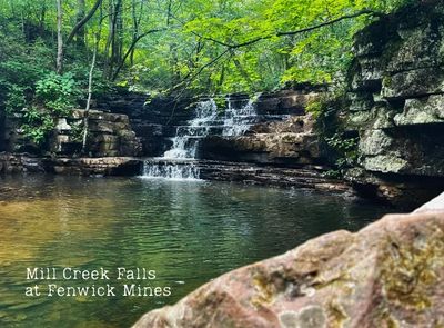
With an easy difficulty rating and an elevation of 1,407 feet, Fenwick Forest Walk in Craig County, Virginia, is an ideal stop for families, nature lovers, birdwatchers, and anyone looking to slow down and enjoy the outdoors.
Stroll along the mile-long trail as it winds through peaceful wetlands and open forests, where you can spot native wildlife, colorful wildflowers, and unique plant life that thrive in this rich habitat. Keep your eyes peeled for birds, deer, turtles, and other creatures that call this special place home.
Perfect for visitors of all ages and abilities, the trail is wheelchair accessible and offers a relaxing way to connect with nature without a strenuous hike. After your walk, don’t forget to visit the website login for more information on the site’s amenities, which include:
- A large picnic shelter
- Grills for cookouts
- Restrooms
- A stocked fishing pond
Directions
Coordinates: 37.569168, -80.05444
From Roanoke, head towards Craig County, Virginia by taking I-581 North, then take exit 1S to merge onto I-81 S towards Salem. After that, take Exit 141 and turn left onto VA-419 N. Travel for 0.4 miles before turning right onto VA-311 N. Continue for 19 miles, then turn right onto VA-615/Market St. After 5 miles, make a left at SR-611. Next, turn right onto SR-685 and continue for 1.6 miles. Finally, take a right at Old Jeep Rd, then another right at the fork to arrive at the Fenwick Mines Recreation Area. For additional information, you may need to access the website login for resources related to Craig County, Virginia.
Adventure Pairing: Pinetop Restaurant
After a day of exploring the stunning trails, scenic byways, and mountain views of Craig County, Virginia, make your next stop Pinetop Restaurant, a longtime local favorite celebrated for hearty meals and warm hospitality.
Nestled in the beautiful mountains of Craig County, Pinetop offers the ideal ambiance to relax, refuel, and swap stories from your adventures. Whether you're in need of a classic country breakfast before an early hike or a satisfying meal after a day outdoors, you will find generous portions and friendly service waiting for you.
Why Pair It With Your Adventure?
- Convenient stop before or after a day enjoying Craig County Virginia's great outdoors
- Classic comfort food and local favorites to satisfy your cravings
- Relaxed, family-friendly atmosphere that feels like home
- A true taste of Craig County hospitality that will make you feel welcome every time you log in to your next adventure.
Ferrier Trail and Lick Branch Loop
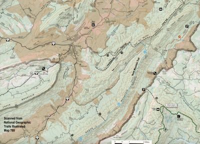
With an easy difficulty rating and an elevation of 1,407 feet, Fenwick Forest Walk in Craig County, Virginia, is an ideal stop for families, nature lovers, birdwatchers, and anyone looking to slow down and enjoy the outdoors.
Stroll along the mile-long trail as it winds through peaceful wetlands and open forests, where you can spot native wildlife, colorful wildflowers, and unique plant life that thrive in this rich habitat. Keep your eyes peeled for birds, deer, turtles, and other creatures that call this special place home.
Perfect for visitors of all ages and abilities, the trail is wheelchair accessible and offers a relaxing way to connect with nature without a strenuous hike. After your walk, don’t forget to visit the website login for more information on the site’s amenities, which include:
- A large picnic shelter
- Grills for cookouts
- Restrooms
- A stocked fishing pond
Directions
Coordinates: 37.569168, -80.05444
From Roanoke, head towards Craig County, Virginia by taking I-581 North, then take exit 1S to merge onto I-81 S towards Salem. After that, take Exit 141 and turn left onto VA-419 N. Travel for 0.4 miles before turning right onto VA-311 N. Continue for 19 miles, then turn right onto VA-615/Market St. After 5 miles, make a left at SR-611. Next, turn right onto SR-685 and continue for 1.6 miles. Finally, take a right at Old Jeep Rd, then another right at the fork to arrive at the Fenwick Mines Recreation Area. For additional information, you may need to access the website login for resources related to Craig County, Virginia.
Adventure Pairing: Bibo's Pizzeria
After a day of exploring the stunning trails, scenic byways, and mountain views of Craig County, Virginia, make your next stop Pinetop Restaurant, a longtime local favorite celebrated for hearty meals and warm hospitality.
Nestled in the beautiful mountains of Craig County, Pinetop offers the ideal ambiance to relax, refuel, and swap stories from your adventures. Whether you're in need of a classic country breakfast before an early hike or a satisfying meal after a day outdoors, you will find generous portions and friendly service waiting for you.
Why Pair It With Your Adventure?
- Convenient stop before or after a day enjoying Craig County Virginia's great outdoors
- Classic comfort food and local favorites to satisfy your cravings
- Relaxed, family-friendly atmosphere that feels like home
- A true taste of Craig County hospitality that will make you feel welcome every time you log in to your next adventure.
Hanging Rock Overlook Trail
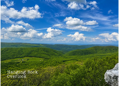
With an easy difficulty rating and an elevation of 1,407 feet, Fenwick Forest Walk in Craig County, Virginia, is an ideal stop for families, nature lovers, birdwatchers, and anyone looking to slow down and enjoy the outdoors.
Stroll along the mile-long trail as it winds through peaceful wetlands and open forests, where you can spot native wildlife, colorful wildflowers, and unique plant life that thrive in this rich habitat. Keep your eyes peeled for birds, deer, turtles, and other creatures that call this special place home.
Perfect for visitors of all ages and abilities, the trail is wheelchair accessible and offers a relaxing way to connect with nature without a strenuous hike. After your walk, don’t forget to visit the website login for more information on the site’s amenities, which include:
- A large picnic shelter
- Grills for cookouts
- Restrooms
- A stocked fishing pond
Directions
Coordinates: 37.569168, -80.05444
From Roanoke, head towards Craig County, Virginia by taking I-581 North, then take exit 1S to merge onto I-81 S towards Salem. After that, take Exit 141 and turn left onto VA-419 N. Travel for 0.4 miles before turning right onto VA-311 N. Continue for 19 miles, then turn right onto VA-615/Market St. After 5 miles, make a left at SR-611. Next, turn right onto SR-685 and continue for 1.6 miles. Finally, take a right at Old Jeep Rd, then another right at the fork to arrive at the Fenwick Mines Recreation Area. For additional information, you may need to access the website login for resources related to Craig County, Virginia.
Adventure Pairing: Swinging Bridge Restaurant
After a day of exploring the stunning trails, scenic byways, and mountain views of Craig County, Virginia, make your next stop Pinetop Restaurant, a longtime local favorite celebrated for hearty meals and warm hospitality.
Nestled in the beautiful mountains of Craig County, Pinetop offers the ideal ambiance to relax, refuel, and swap stories from your adventures. Whether you're in need of a classic country breakfast before an early hike or a satisfying meal after a day outdoors, you will find generous portions and friendly service waiting for you.
Why Pair It With Your Adventure?
- Convenient stop before or after a day enjoying Craig County Virginia's great outdoors
- Classic comfort food and local favorites to satisfy your cravings
- Relaxed, family-friendly atmosphere that feels like home
- A true taste of Craig County hospitality that will make you feel welcome every time you log in to your next adventure.
Lipes Branch Trail
.png/:/rs=w:400,cg:true,m)
With an easy difficulty rating and an elevation of 1,407 feet, Fenwick Forest Walk in Craig County, Virginia, is an ideal stop for families, nature lovers, birdwatchers, and anyone looking to slow down and enjoy the outdoors.
Stroll along the mile-long trail as it winds through peaceful wetlands and open forests, where you can spot native wildlife, colorful wildflowers, and unique plant life that thrive in this rich habitat. Keep your eyes peeled for birds, deer, turtles, and other creatures that call this special place home.
Perfect for visitors of all ages and abilities, the trail is wheelchair accessible and offers a relaxing way to connect with nature without a strenuous hike. After your walk, don’t forget to visit the website login for more information on the site’s amenities, which include:
- A large picnic shelter
- Grills for cookouts
- Restrooms
- A stocked fishing pond
Directions
Coordinates: 37.569168, -80.05444
From Roanoke, head towards Craig County, Virginia by taking I-581 North, then take exit 1S to merge onto I-81 S towards Salem. After that, take Exit 141 and turn left onto VA-419 N. Travel for 0.4 miles before turning right onto VA-311 N. Continue for 19 miles, then turn right onto VA-615/Market St. After 5 miles, make a left at SR-611. Next, turn right onto SR-685 and continue for 1.6 miles. Finally, take a right at Old Jeep Rd, then another right at the fork to arrive at the Fenwick Mines Recreation Area. For additional information, you may need to access the website login for resources related to Craig County, Virginia.
Adventure Pairing: The Lemon Hotel
After a day of exploring the stunning trails, scenic byways, and mountain views of Craig County, Virginia, make your next stop Pinetop Restaurant, a longtime local favorite celebrated for hearty meals and warm hospitality.
Nestled in the beautiful mountains of Craig County, Pinetop offers the ideal ambiance to relax, refuel, and swap stories from your adventures. Whether you're in need of a classic country breakfast before an early hike or a satisfying meal after a day outdoors, you will find generous portions and friendly service waiting for you.
Why Pair It With Your Adventure?
- Convenient stop before or after a day enjoying Craig County Virginia's great outdoors
- Classic comfort food and local favorites to satisfy your cravings
- Relaxed, family-friendly atmosphere that feels like home
- A true taste of Craig County hospitality that will make you feel welcome every time you log in to your next adventure.
The Pines Campground
.png/:/rs=w:400,cg:true,m)
With an easy difficulty rating and an elevation of 1,407 feet, Fenwick Forest Walk in Craig County, Virginia, is an ideal stop for families, nature lovers, birdwatchers, and anyone looking to slow down and enjoy the outdoors.
Stroll along the mile-long trail as it winds through peaceful wetlands and open forests, where you can spot native wildlife, colorful wildflowers, and unique plant life that thrive in this rich habitat. Keep your eyes peeled for birds, deer, turtles, and other creatures that call this special place home.
Perfect for visitors of all ages and abilities, the trail is wheelchair accessible and offers a relaxing way to connect with nature without a strenuous hike. After your walk, don’t forget to visit the website login for more information on the site’s amenities, which include:
- A large picnic shelter
- Grills for cookouts
- Restrooms
- A stocked fishing pond
Directions
Coordinates: 37.569168, -80.05444
From Roanoke, head towards Craig County, Virginia by taking I-581 North, then take exit 1S to merge onto I-81 S towards Salem. After that, take Exit 141 and turn left onto VA-419 N. Travel for 0.4 miles before turning right onto VA-311 N. Continue for 19 miles, then turn right onto VA-615/Market St. After 5 miles, make a left at SR-611. Next, turn right onto SR-685 and continue for 1.6 miles. Finally, take a right at Old Jeep Rd, then another right at the fork to arrive at the Fenwick Mines Recreation Area. For additional information, you may need to access the website login for resources related to Craig County, Virginia.
Adventure Pairing: Potts Mountain Jeep Trail
After a day of exploring the stunning trails, scenic byways, and mountain views of Craig County, Virginia, make your next stop Pinetop Restaurant, a longtime local favorite celebrated for hearty meals and warm hospitality.
Nestled in the beautiful mountains of Craig County, Pinetop offers the ideal ambiance to relax, refuel, and swap stories from your adventures. Whether you're in need of a classic country breakfast before an early hike or a satisfying meal after a day outdoors, you will find generous portions and friendly service waiting for you.
Why Pair It With Your Adventure?
- Convenient stop before or after a day enjoying Craig County Virginia's great outdoors
- Classic comfort food and local favorites to satisfy your cravings
- Relaxed, family-friendly atmosphere that feels like home
- A true taste of Craig County hospitality that will make you feel welcome every time you log in to your next adventure.
Wilderness Adventure at Eagle Landing
.png/:/rs=w:400,cg:true,m)
With an easy difficulty rating and an elevation of 1,407 feet, Fenwick Forest Walk in Craig County, Virginia, is an ideal stop for families, nature lovers, birdwatchers, and anyone looking to slow down and enjoy the outdoors.
Stroll along the mile-long trail as it winds through peaceful wetlands and open forests, where you can spot native wildlife, colorful wildflowers, and unique plant life that thrive in this rich habitat. Keep your eyes peeled for birds, deer, turtles, and other creatures that call this special place home.
Perfect for visitors of all ages and abilities, the trail is wheelchair accessible and offers a relaxing way to connect with nature without a strenuous hike. After your walk, don’t forget to visit the website login for more information on the site’s amenities, which include:
- A large picnic shelter
- Grills for cookouts
- Restrooms
- A stocked fishing pond
Directions
Coordinates: 37.569168, -80.05444
From Roanoke, head towards Craig County, Virginia by taking I-581 North, then take exit 1S to merge onto I-81 S towards Salem. After that, take Exit 141 and turn left onto VA-419 N. Travel for 0.4 miles before turning right onto VA-311 N. Continue for 19 miles, then turn right onto VA-615/Market St. After 5 miles, make a left at SR-611. Next, turn right onto SR-685 and continue for 1.6 miles. Finally, take a right at Old Jeep Rd, then another right at the fork to arrive at the Fenwick Mines Recreation Area. For additional information, you may need to access the website login for resources related to Craig County, Virginia.
Adventure Pairing: Lemon & Vale Cakery
After a day of exploring the stunning trails, scenic byways, and mountain views of Craig County, Virginia, make your next stop Pinetop Restaurant, a longtime local favorite celebrated for hearty meals and warm hospitality.
Nestled in the beautiful mountains of Craig County, Pinetop offers the ideal ambiance to relax, refuel, and swap stories from your adventures. Whether you're in need of a classic country breakfast before an early hike or a satisfying meal after a day outdoors, you will find generous portions and friendly service waiting for you.
Why Pair It With Your Adventure?
- Convenient stop before or after a day enjoying Craig County Virginia's great outdoors
- Classic comfort food and local favorites to satisfy your cravings
- Relaxed, family-friendly atmosphere that feels like home
- A true taste of Craig County hospitality that will make you feel welcome every time you log in to your next adventure.